CONTEXT of DEPRIMAP
The world is witnessing an unprecedented rate of urbanization, particularly in the Majority World (MW), which includes regions such as Sub-Saharan Africa, Latin America, and South Asia. This rapid urban growth has led to the proliferation
of deprived urban areas (DUAs), where millions of people live in conditions that are far below the standards of planned, affluent neighborhoods. By 2030, it is projected that over 2 billion people will reside in
these vulnerable areas.
Challenges of Deprived Urban Areas
DUAs are characterized by overcrowding, inadequate infrastructure, limited access to basic services, and heightened exposure to environmental hazards. These areas are often located in high-risk zones prone to flooding, drought, and extreme heat, making their populations particularly vulnerable to the effects of climate change. Additionally, residents of DUAs face greater risks of infectious diseases and other health-related issues due to poor living conditions.
Despite the critical need for targeted interventions, the data available to monitor and understand DUAs is often incomplete or inconsistent. Traditional urban planning and policy-making processes have struggled to address the unique challenges faced by these communities, largely due to the lack of reliable and detailed information.
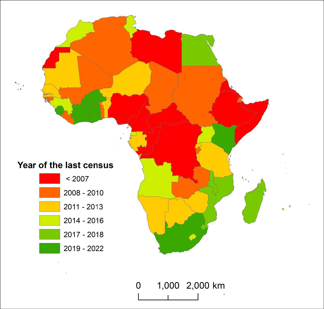
As illustrated in the below figure, several African countries have not conducted a census in over a decade, using 2022 as the reference year. This severely complicates efforts to gather accurate and up-to-date data
about DUAs. Even when censuses are conducted, these settlements are often under-sampled or entirely excluded from official sampling efforts. For example research by Thomson et al. 2021 has shown that even the most accurate gridded
population estimates capture only 39% of the population living in slums. This under-representation hampers progress on Sustainable Development Goals (SDGs), particularly those focused on reducing poverty, inequality,
and the impacts of climate change.

The absence of reliable data can lead to misleading and unreliable estimates being provided to authorities and stakeholders, such as UN-Habitat. Furthermore, little is known about the spatial and built characteristics of DUAs, such as their street patterns, the availability of open spaces, and their overall connectivity to the city. This lack of knowledge extends to their vulnerability to natural hazards like floods and heatwaves.
In Latin America, particularly in Argentina, DUAs are known as “villas” and are characterized by inadequate urban infrastructure, including the absence of green or recreational spaces and streets that can accommodate vehicular traffic. In these areas, residents mostly traverse through narrow corridors due to the scarcity of land. Buenos Aires, for instance, has shown strong correlations between urbanization, poverty, and adverse health outcomes, including increased mortality rates and disease burdens. The rapid urbanization of the city has also resulted in unequal distribution of risk related to natural hazards.
In Southeast Asia, Bangladesh’s capital city Dhaka, with a population projected to exceed 12 million by 2023, has experienced significant urban growth since 1975. Its DUAs are becoming increasingly vulnerable to natural hazards such as floods. The city’s high population density, coupled with its rapid expansion, exacerbates the challenges in managing these risks.
While recent studies have confirmed the extreme diversity in the physical morphology of DUAs across different regions, our overall understanding of these areas remains limited. There is still a pressing need for more detailed and reliable
data to guide effective urban planning and policy development.
Addressing the Data Gap
DEPRIMAP was conceived to fill this critical gap in knowledge and data. Our project seeks to develop a comprehensive geospatial framework that leverages cutting-edge technologies, including satellite data from the Copernicus program and advanced machine learning techniques. By doing so, we aim to map, model, and characterize DUAs across a geographically diverse set of case studies, including cities like Buenos Aires, Khartoum, Lagos, Nairobi, and Dhaka (tentative locations).
By employing these innovative appraoches, DEPRIMAP will contribute to a deeper understanding of the physical, demographic, and socio-economic characteristics of DUAs. This information will provide actionable insights for urban planners, policymakers, and stakeholders, enabling them to make informed decisions that promote sustainable and resilient urban development.
Furthermore, the project will address key questions about the exposure and vulnerability of DUAs to natural hazards such as flooding, drought, and heatwaves. Through this, DEPRIMAP aims to contribute to global efforts towards achieving
Sustainable Development Goals (SDGs), particularly those focused on reducing inequality, combating climate change, and building inclusive and resilient cities.
The Importance of Community and Stakeholder Engagement
One of the core principles of DEPRIMAP is the active involvement of local communities and stakeholders in the research process. We believe that sustainable solutions can only be achieved through collaborative efforts that take into account the perspectives and needs of those who are most affected by urban deprivation. By engaging with community leaders, local governments, and international organizations, DEPRIMAP ensures that its findings are
relevant, actionable, and capable of driving meaningful change.
DEPRIMAP is a research funded by FORMAS (Swedish Research Council, application 2023-01210) involving KAU (Karlstad University, Sweden)

