Bringing DEPRIMAP to Life
The DEPRIMAP project is structured around a series of well-defined work packages and activities designed to achieve its ambitious goals. This implementation plan outlines the key components of the project, detailing how we will carry
out research, engage with stakeholders, and deliver impactful results.
Project Structure and Work Packages
DEPRIMAP is organized into several Thematic Work Packages (TWPs), each focused on a specific aspect of the research. These TWPs are interconnected, ensuring a comprehensive approach to addressing the challenges of deprived urban areas
(DUAs).
TWP 1: Data Collection and Pre-processing
Objective
The primary goal of this work package is to assemble, curate, and pre-process the necessary geospatial datasets for mapping and analyzing deprived urban areas (DUAs). By utilizing diverse data resources, this package will establish
a robust data foundation that supports the project’s broader objectives.
Activities
Systematic Review of Geospatial Datasets:
A thorough review will be conducted to identify publicly accessible geospatial and Earth Observation (EO) datasets for mapping DUAs. These datasets will be crucial for extracting urban morphology and population data in these areas, as well as for integration with machine learning models.
Publicly available building footprint datasets, such as those from Google and Microsoft, along with street network data, will be used to examine urban structures in innovative ways. For example, Microsoft’s Road Detections dataset will allow us to explore how street layouts contribute to urban connectivity and resilience in DUAs.
Acquisition of High-Resolution Satellite Data:
High-resolution EO data from Copernicus satellites, particularly Sentinel-1 and Sentinel-2, will be central to the project. These sensors provide regular coverage and have been widely used in urban applications, making them ideal for scalable solutions like DEPRIMAP. In addition, MODIS-derived Land Surface Temperature (LST) imagery will be used to assess environmental conditions in the cities of interest. Historical data on flooded areas in cities such as Lagos and Dhaka will also be gathered for further analysis.
Pre-prcoessing of Data:
The datasets will be pre-processed to ensure they are ready for use in the project’s analytical models. This includes preparing building footprints, street networks, population distribution grids (such as those form WorldPop), and other relevant exposure indicators. These baseline datasets will also be used to compare the accuracy of DEPRIMAP’s machine learning-driven population models.
Training and Validation Data:
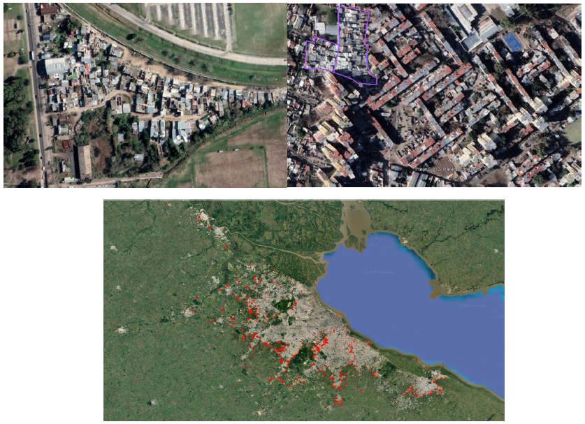
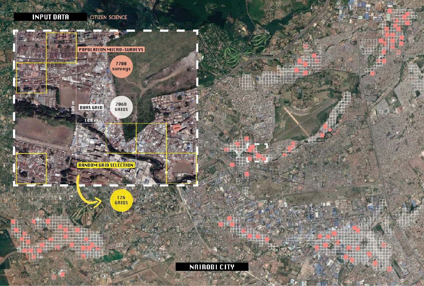
To train and validate the project’s models, we will incorporate socio-economic data from available censuses and micro-surveys. For example, the Figure-A shows an extensive dataset of DUAs in Buenos Aires, highlighting common urban
configurations. Similar datasets are available for other case study cities, including a detailed grid-level socio-economic survey from Nairobi (Figure-B), which will also be used to support model development and validation.


TWP 2: Characterizing DUA Morphology
Objective
The primary aim of this work package is to develop and apply a robust methodological framework to better understand the morphology of DUAs across different parts of the Majority World. Using advanced data and techniques, this work
package seeks to map, identify, and analyze the unique characteristics of DUAs.
Activities
Development of Machine Learning Models:
Advanced machine learning (ML) algorithms will be developed and deployed to identify and map DUAs across the selected case studies. These models will leverage data from TWP 1, including building footprints, street networks, and Sentinel satellite imagery. By focusing on scalable solutions, the models will be designed to handle large datasets across different regions.
Morphometrics and DUA Morphology:
A key component of this TWP is the introduction of morphometrics, a set of metrics designed to quantify the spatial configurations of streets, buildings, and open spaces within DUAs. Morphometrics can reveal critical insights into the urban form, such as building patterns, road connectivity, and the degree of openness within DUAs, which are often associated with levels of deprivation. By applying morphometrics to raw data, we aim to identify unique urban features that are not visible in traditional datasets.
Comparative Studies of DUAs and Non-DUAs:
Comparative analysis will be conducted between DUAs and non-DUAs, focusing on key indicators such as openness, vegetation cover, and the arrangement of built-up areas. These analyses will help uncover the spatial and functional differences between these areas, allowing us to better understand how DUAs are organized and how they differ from more affluent parts of the city.
Integration of Satellite and Socio-Economic Data:
In addition to using Sentinel-1 and Sentinel-1 imagery, the project will incorporate socio-economic data from censuses and surveys where applicable. This will allow us to link the physical characteristics of DUAs with social and economic indicators, providing a more holistic understanding of these communities. For instance, road connectivity and open space metrics will be examined in relation to population density and economic activity within DUAs.
Transferability and Scalability of Models:
An essential focus of this TWP is the development of transferable machine learning models that can be applied across different cities. To mitigate the effects of data scarcity in certain regions, we will use domain adaptation techniques
that allow models trained in one city to be applied to another. This approach ensures that our findings are scalable and can be generalized to a wider range of urban contexts.
TWP 3: Assessing Vulnerability and Exposure
Objective
The primary objective of this work package is to quantify the vulnerability and exposure of DUAs to natural hazards and other risks, comparing them to more affluent urban areas. By assessing the functional differences between DUAs
and non-DUAs, we aim to provide actionable insights into the unique risks faced by these communities.
Activities
Predicting Population Distribution and Density in DUAs:
DUAs are often suffer from outdated or unreliable census data, leading to significant gaps in understanding their population dynamics. To address this, deep learning (DL) algorithms will be developed and applied, using Earth Observation (EO) and geospatial datasets to predict population distribution and density within DUAs. These models will be enhanced by incorporating citizen-collected data, such as self-reported population estimates from initiatives like ‘Slum Dwellers International’, which provides grassroots insights into DUA populations.
Previous research has shown that using Sentinel-1 imagery and building footprint data can effectively predict population patterns, even in areas with minimal training data. This framework will be adapted for DUAs, ensuring that population density models are accurate, scalable, and suited for data-scarce environments.
Assessing Exposure to Natural Hazards:
DUAs are often located in high-risk areas, making them more vulnerable to natural hazards such as floods, droughts, and heatwaves. Using EO data and satellite-derived layers, this TWP will systematically investigate the exposure of DUA residents to these hazards. For instance:
- In Dhaka and Lagos, flood risks could be analyzed using historical flood maps.
- In Buenos Aires, Nairobi, and Khartoum, the focus will be on heatwaves, with Land Surface Temperature (LST) data providing crucial insights into the impact of extreme heat on urban populations.
Comparative Risk Analysis:
A comparative risk analysis will be conducted between DUAs and non-DUAs, focusing on the disparities in exposure and vulnerability to natural hazards. The standard risk frameworks will be applied, where Risk (R) is a function of Hazard (H), Exposure (E), and Vulnerability (V).
R = f (H, E, V)
- Hazard refers to the probability of occurrence of a given natural event (e.g., floods and heatwaves).
- Exposure represents the population and assets that are located in hazard-prone zones.
- Vulnerability assesses how the intensity of a hazard translates into potential losses for affected population and infrastructure.
By applying this framework, DEPRIMAP will quantify the risk faced by DUA residents and determine if these populations are disproportionately affected by these hazards compared to more affluent urban areas. This analysis will highlight
critical disparities and help inform targeted interventions.
TWP 4: Stakeholder Engagement and Dissemination
Objective
To ensure that DEPRIMAP’s research is informed by and responsive to the needs of key stakeholders, including local communities, government officials, and global organizations. The work package also focuses on effectively disseminating
the project’s findings to maximize its impact and foster informed decision-making.
Activities
Stakeholder Collaboration and Engagement:
DEPRIMAP places significant emphasis on engaging with stakeholders from the outset of the project. A detailed dissemination plan will be laid out during the initial meetings involving key stakeholders including international, national & regional organization and local DUA community leaders. This bottom-up approach ensures that the project is supported by and aligned with the needs of the communities we aim to serve.
Workshops, Webinars, and Information Sessions:
Throughout the project’s duration, DEPRIMAP will maintain regular engagement with stakeholders via workshops, webinars, and information sessions. These platforms will provide an opportunity for dialogue, feedback, and collaborative problem-solving. In addition to connecting with local communities, DEPRIMAP will collaborate with other projects and initiatives addressing urban deprivation to share knowledge and strengthen the global network of urban researchers and practitioners.
Global Forums and Conferences:
As part of the dissemination strategy, DEPRIMAP will organize and participate in panel sessions at major international forums, including the World Urban Forum. These sessions will provide an opportunity to present the project’s findings to a global audience of policymakers, urban planners, local government officials, and non-governmental organizations working across the Majority World.
Publication and Open Access:
To contribute to the global body of knowledge on urban deprivation, DEPRIMAP aims to publish open-access scientific articles in international journals. These publications will ensure that the project’s findings are accessible to researchers, practitioners, and policymakers worldwide. Additionally, DEPRIMAP will develop a publicly accessible data repository, making the project’s data available for further research and application.
Long-term Stakeholder Engagement:
Stakeholder engagement will not be limited to the project’s initial phases but will be maintained throughout its lifecycle. Regular updates, workshops, and information meetings will ensure that stakeholders remain informed and involved.
This continuous engagement will help align the project’s outputs with the evolving needs of DUA communities and other key factors.
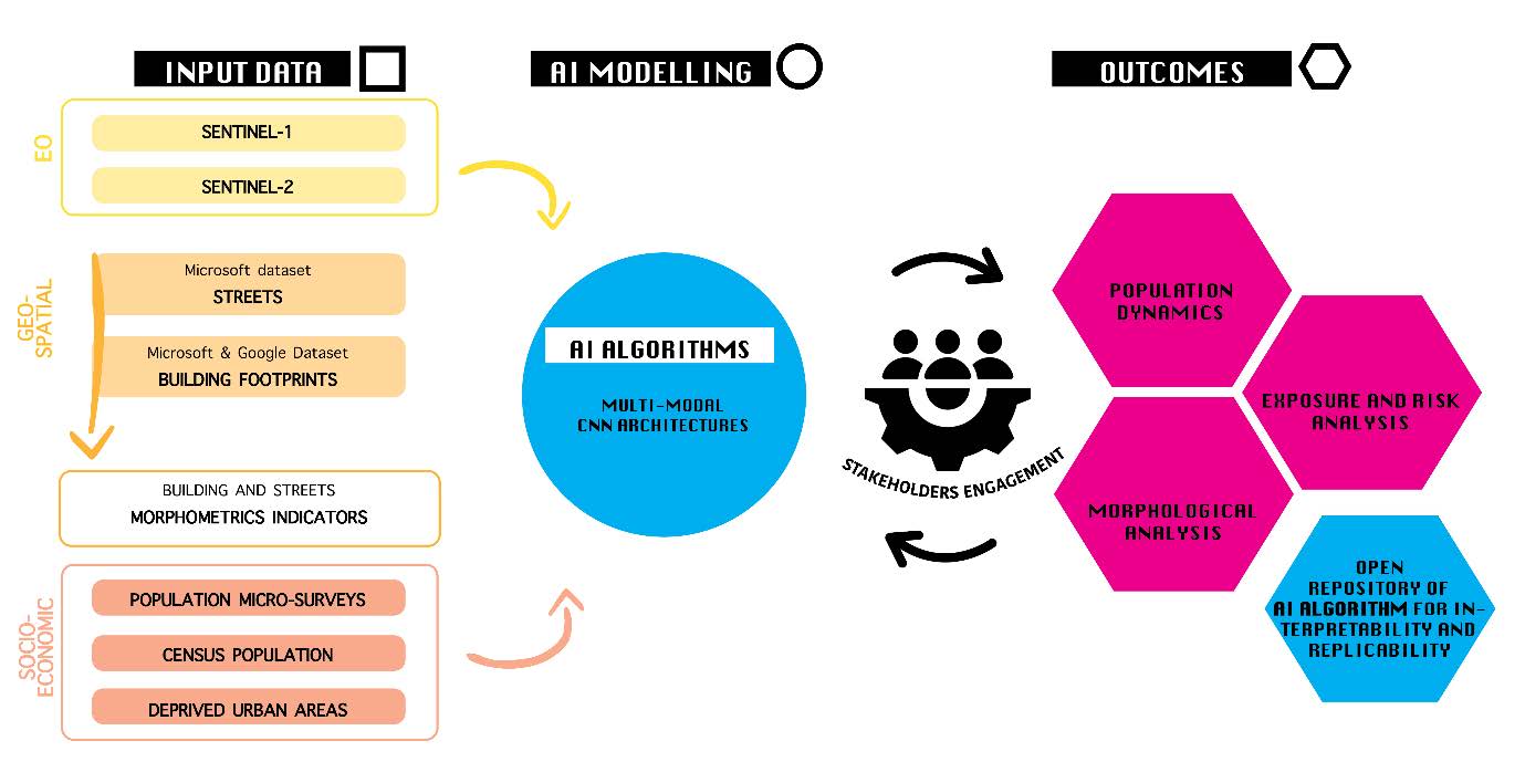
Methodological Framework

DEPRIMAP is a research funded by FORMAS (Swedish Research Council, application 2023-01210) involving KAU (Karlstad University, Sweden)

