
Reflections from the ESA Living Planet Symposium 2025: Earth Observation, Innovation, and Insights for DEPRIMAP
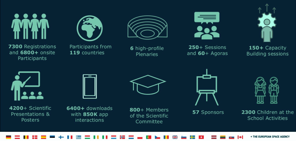
In June 2025, Sai Ganesh Veeravalli had the opportunity to attend the ESA Living Planet Symposium 2025 held in Vienna, Austria, an event that brought together nearly 7,000 participants from 119 countries. The scale of the symposium was impressive, and at times overwhelming, but ultimately it served as a powerful reminder of the global momentum driving Earth Observation (EO) science and its far-reaching impact across disciplines.
The week-long event featured a rich mix of plenary sessions, tutorial workshops, ESA mission briefings, poster and oral presentations, capacity-building sessions, and dedicated corners for space agencies, startups, and data providers. Whether you were interested in climate resilience, urban change, biodiversity, or frontier AI models, there was truly something for everyone, no matter how niche your topic might be.

For someone working at the intersection of EO and urban deprivation mapping, the symposium offered not just scientific insights but also space for reflection: on the state of our tools, the inclusiveness of our data ecosystems, and the real-world usability of our research.
Tutorial Sessions: Exploring tools for DEPRIMAP
Among the many parallel sessions and events, Sai Ganesh made a deliberate effort to attend tutorial sessions that could have practical value for the DEPRIMAP project, particularly for streamlining large-scale workflows and improving processing efficiency. Three tools stood out, each offering potential to enhance different stages of our work.
1. TorchGeo
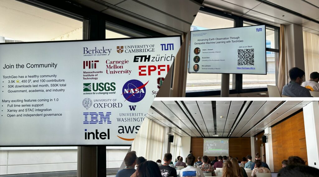
This PyTorch-based library is designed specifically for deep learning with geospatial data. It stood out for its range of built-in loaders and access to pre-trained models, which could be highly relevant for the second phase of DEPRIMAP. In particular, when we shift toward population modelling using diverse EO inputs, TorchGeo may offer a flexible and scalable approach to develop deep learning models that integrate multiple datasets.
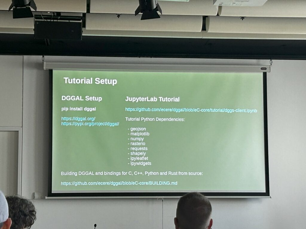
The Discrete Global Grid System (DGGS) and its abstraction library (DGGAL) provide a globally standardised way of representing spatial data as hierarchical, equal-area grids. This could be particularly useful for our ISLAND model, which operates at the grid-level, and we plan to scale to more than 5,000 cities across the Global South. While we will need to test its compatibility with our existing pipeline, DGGS offers a promising alternative to traditional UTM-based tiling, especially for comparisons across cities and countries.
3. JuliaGEO
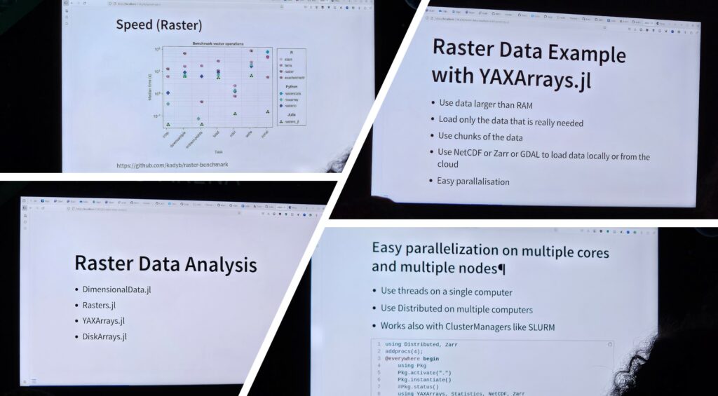
While still new to the geospatial community, JuliaGeo caught our attention because of its claim of significantly faster geospatial processing compared to Python. Given that much of DEPRIMAP’s processing involves larger raster datasets, like Google’s 2.5D building data, NDVI, LST and others, speed gains could substantially reduce computational overhead. Initial testing is planned to evaluate whether the Julia ecosystem can offer meaningful performance improvements for our workflow.
In an unexpected but meaningful moment, Sai Ganesh also met Martin Fleischmann, the creator of the Python package momepy that we often use in our morphometric analysis. It was encouraging to find that Martin is familiar with our research network, including collaborators like Monika Kuffer and Jon Wang from Faculty ITC, University of Twente. We had a thoughtful discussion about optimising workflows when working with limited computing resources, and he shared several tips that we hope to try in the coming weeks.
Martin also introduced us to a new package he developed called xvec, which enables vector data cubes within the Xarray ecosystem. This could be a game-changer for organising and processing large volumes of vector-based spatial data in a more structured and memory-efficient way, especially relevant for the thousands of city segments we plan to analyse.
Emerging datasets for Urban and Environmental monitoring
In addition to tools and tutorials, the symposium was a hotspot for discovering new Earth Observation datasets, many of which could directly support DEPRIMAP’s objectives of mapping deprivation, tracking urban change and modelling infrastructure gaps.
At the Google Earth Engine (GEE) booth, two newly released datasets particularly caught our attention:
This dataset provides a per-pixel score (ranging from 0 to 1) that reflects whether a 30-meter pixel was occupied by undisturbed forest in 2020. What makes it unique is its ensemble-based approach: it combines multiple forest cover datasets using a convergence-of-evidence methodology. While DEPRIMAP doesn’t directly work with forests, the underlying logic of fusing datasets to derive interpretable indices offers inspiration for how we might think about composite indicators of deprivation or built-up expansion.
Unlike conventional spectral bands, this global dataset provides 64-dimensional embeddings for each 10-meter pixel. These embeddings summarise the temporal and contextual EO signal using learned features from multiple instruments, making them ideal for downstream machine learning. For DEPRIMAP’s upcoming work in modelling settlement types or predicting population density, such high-dimensional, analysis-ready inputs open up exciting possibilities.
Beyond GEE, we also took note of several other datasets presented across booths and sessions:
- EC-JRC’s updated Global Human Settlement Layer (GHSL) – now available at 10m resolution, open-access, and regularly updated.
- World Settlement Footprint (WSF) – another high-resolution product offering temporal snapshots of built-up areas.
- NOAA VIIRS Nightime Lights and Luojia-1 Nightime lights – valuable for proxies of infrastructure and economic activity.
- LST CCI (Land Surface Temperature Climate Change Initiative) – useful for analysing microclimate variations in urban spaces.
Taken together, these datasets point toward an increasingly rich data environment for urban EO research. The challenge and opportunity will be in designing efficient pipelines and choosing the right combinations of inputs that align with DEPRIMAP’s core research questions.
Plenaries and Policy Dialogues: Urbanization, Data gaps, and the role of EO
The plenary sessions at Living Planet 2025 offered far more than ceremonial keynotes; they were deeply reflective of the broader state of Earth Observation, its growing role in sustainable development, and its limitations. Several sessions resonated strongly with the core challenges DEPRIMAP seeks to address.
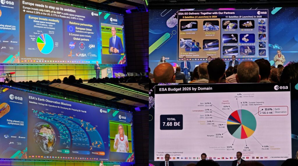
In the opening session, ESA Director General highlighted that over 30% of ESA’s €7.7 billion budget is now allocated to Earth Observation, with 28 satellites in operation and 40 more missions under preparation.
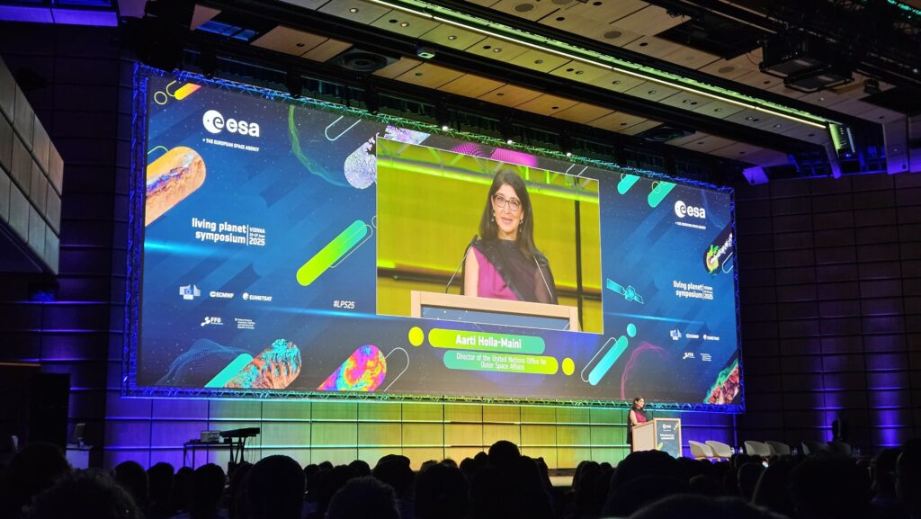
Despite this impressive scale, Aarti Holla-Maini, Director of the United Nations Office for Outer Space Affairs (UNOOSA), raised a critical concern: while petabytes of EO data are generated and archived, the return on investment remains questionable because the data is not reaching or empowering the people who need it most. The fragmentation of tools, incompatible resolutions, and the lack of actionable interfaces mean many sectors remain disconnected from EO’s potential.
Her framing of UN 2.0 – an agenda fusing EO data, behavioural science and policy making aligns well with DEPRIMAP’s intent to move beyond just data extraction to usable, context-specific knowledge systems. The call for sector-specific toolkits, APIs, and dashboards for SDG monitoring is particularly relevant as we scale the DEPRIMAP framework for operational use.
One of the most thought-provoking panels focused on the role of cities in using EO for advancing policy. Key voices like Dyfed Aubrey, Monika Kuffer, Thomas Kemper, and Yifang Ban discussed the realities of urbanisation in the Global South, where 90% of future urban growth is expected, and the critical blind spots in how we map, monitor, and serve informal settlements.
Some major takeaways:
- 1.1 billion people currently live in slums (UN-Habitat).
- Urban growth is surging in secondary cities and peri-urban zones, often overlooked in administrative datasets.
- Health, infrastructure, and service delivery surveys often miss informal areas, leading to misinformed planning.
- High-resolution data must be simplified and translated into interpretations, not just layers, to be meaningful for users.
- Co-creation and local validation are essential, especially when EO-based products are applied in unfamiliar, complex socio-complex contexts.
The panel emphasised the risk of applying models trained in the data-rich Global North directly to Global South contexts. As DEPRIMAP explores city-scale modelling, these warnings about bias, generalizability, and user-centred design are timely reminders to centre our workflows around local realities, not just data availability.

Final Thoughts
Attending the ESA Living Planet Symposium 2025 was more than just an opportunity to learn about the latest datasets, tools, and satellite missions; it was a much-needed moment to pause and reflect on where we stand as a research community. It reminded me that while our models and metrics are important, their true value lies in how they are understood, used, and adapted by the people they are meant to serve.
For DEPRIMAP, the lessons were both strategic and technical: the need to simplify and co-create EO products, the importance of capacity development and local engagement, and the potential of new libraries like TorchGeo, xvec, and DGGS-based architectures to strengthen our workflows. We return with a longer reader list, several new tools to test, and most importantly, a renewed sense of purpose in making Earth Observation more accessible, actionable, and equitable, especially for the rapidly transforming urban regions of the Global South.
For more updates on our work and reflections from global EO events, stay tuned to the DEPRIMAP website.
No responses yet