PUBLICATIONS
Below is the list of all publications over the years published by the team of DEPRIMAP that are directly or indirectly linked to the project.
Journal Articles
Satellite monitoring for post-clearance accountability: lessons from Rushikonda hill
Sai Ganesh Veeravalli
doi: https://doi.org/10.1007/s44327-025-00130-x
Full citation: Veeravalli, S.G. Satellite monitoring for post-clearance accountability: lessons from Rushikonda hill. Discov Cities 2, 91 (2025). https://doi.org/10.1007/s44327-025-00130-x
Conference Papers
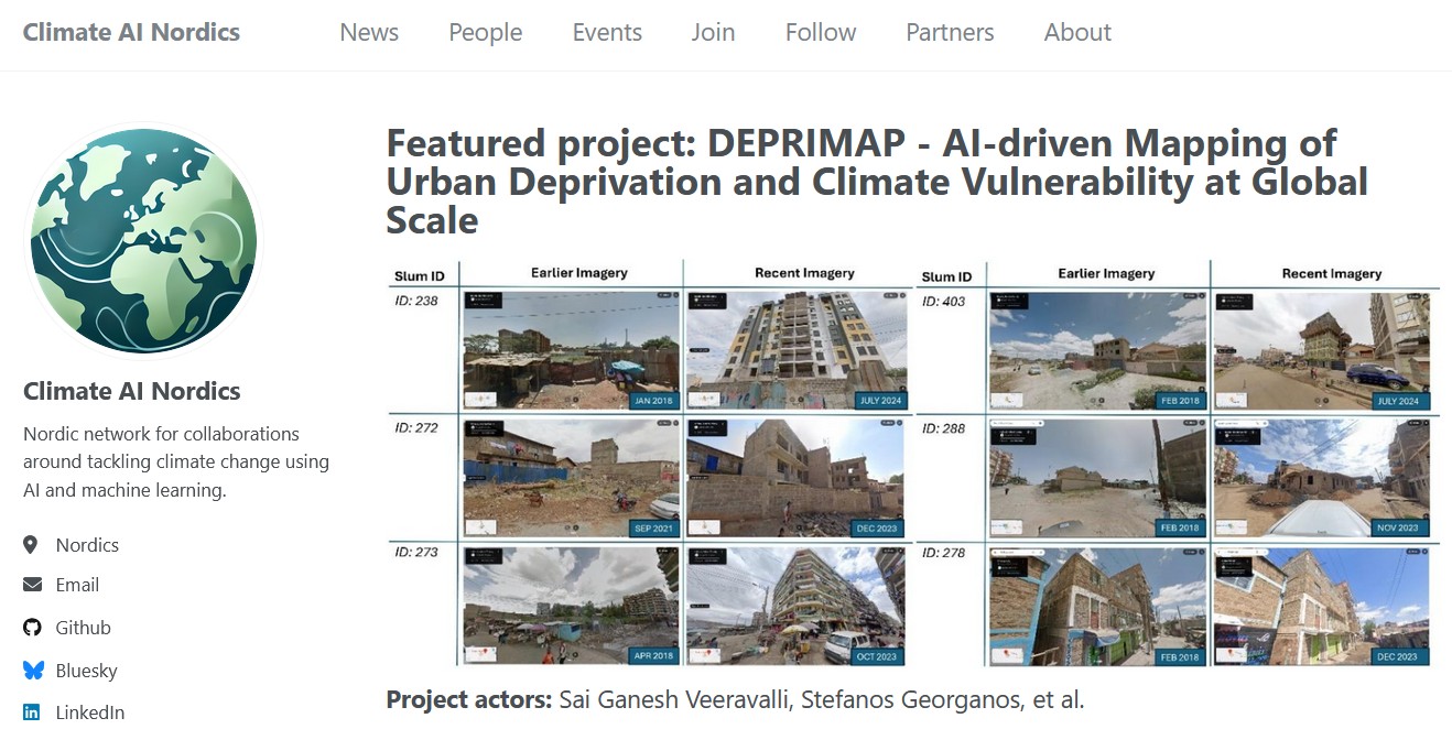
Understanding Informal Settlement Transformation through Google’s 2.5 Dataset and Street View based Validation
Sai Ganesh Veeravalli, Jan Haas, John Friesen, Stefanos Georganos
In 8th Workshop on Global South at 44th EARSeL Symposium
doi: https://doi.org/10.5194/isprs-archives-XLVIII-M-7-2025-245-2025
Full citation: Veeravalli, S. G., Haas, J., Friesen, J., and Georganos, S.: Understanding Informal Settlement Transformation through Google’s 2.5D Dataset and Street View based Validation, Int. Arch. Photogramm. Remote Sens. Spatial Inf. Sci., XLVIII-M-7-2025, 245–251, https://doi.org/10.5194/isprs-archives-XLVIII-M-7-2025-245-2025, 2025.
Code repository: https://github.com/saiga143/urban-change-google-25d
Zenodo repository: Veeravalli, S. G. (2025). Codebase for urban change detection in informal settlements using Google’s 2.5D dataset (v1.1). Zenodo. https://doi.org/10.5281/zenodo.15269825
—
Towards a Spatial Measure of SDG 11.1.1: Open Data for Urban Deprivation Mapping
Sai Ganesh Veeravalli, Florencio Campomanes V, Sebastian Hafner, Stefanos Georganos, Monika Kuffer, John Friesen, Dana R Thomson, Robert Ndugwa, Dennis Mwaniki, Angela Abascal, Peter Elias, Tobi Eniolu Morakinyo, Julio Pedrassoli, Gabriel de Oliveira, Anthony Boanada-Fuchs, Boris Zerjav, Juan Manuel D’Attoli
At Joint Urban Remote Sensing (JURSE) 2025, Tunis Conference
doi: http://dx.doi.org/10.1109/JURSE60372.2025.11076033
Full citation: S. G. Veeravalli et al., “Towards a Spatial Measure of SDG 11.1.1: Open Data for Urban Deprivation Mapping,” 2025 Joint Urban Remote Sensing Event (JURSE), Tunis, Tunisia, 2025, pp. 1-4, doi: 10.1109/JURSE60372.2025.11076033.
DEPRIMAP is a research funded by FORMAS (Swedish Research Council, application 2023-01210) involving KAU (Karlstad University, Sweden)